Posts

Showing posts from July, 2016

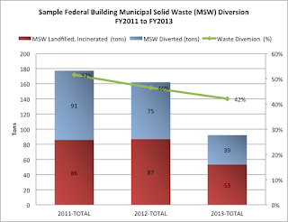
GROUND WATER SOURCES GENERAL REMARKS

Image
The water that is percolated in the ground is known as groundwater.  It is brought on the surface for use. The following points need to be taken into account regarding underground sources: a) AQUIFERS The surface of each aquifers is composed of alternate pervious and impervious layers. Pervious strata are those strata through which water can easily pass while impervious strata are those through which water cannot pass.  The   pervious layers are named as aquifers or water holding strata. Aquifers have sand or gravel layer that provides the good quality water. The aquifers that are made of limestone layer gives good quantity of water supply and cracks or fissures are present there. b) MOVEMENT OF GROUNDWATER The movement of underground water is through gravity and attraction of molecules of surface tension. c) POROSITY   The porosity is defined as the ratio of volume of pores or openings of material to the volume of total volume of material. Porosity is measured in percentage.  P=  V 1

SURFACE WATER RESOURCES AND THEIR WATER QUALITY

Image
SURFACE SOURCES Surface water resources includes three types of sources 1) Lakes and Streams 2) Rivers 3) Storage Reservoirs 1) LAKES AND STREAMS A natural lake is a large water body in the land. A lake is used to supply water to its nearest areas. The runoff of water that goes in the lake should be measured correctly and it should be equal to the demand of that area people. Streams are made by the surface. Streams have plenty of water in rainy season but the flow of water in dry season is quite low and it may cause the streams dry.  The catchment area of both lakes and streams is low. So, the water supply is also low in these water bodies. Therefore, they cannot be used as water supply schemes for large cities. They can only be used for nearby areas and small towns.  Wat er Quality The water of lakes and streams is free from impurities. This water can be utilized safely for drinking water purpose.  2) RIVERS Rivers proves as the large source of water supply schemes for Rivers are clas

VIRTUAL WATER

Image
Virtual Water is the water embodied in a product not in real sense but in virtual sense. The water required to produce a product is known as virtual water. It is also known as embedded water or exogenous water. Exogenous water is the water that the countries import in virtual sense and it is exogenous to the importing countries. In quantitative term one approach defined the virtual water content as volume of water that is used in actual to produce the product. It depends on production conditions such as time and place of production and water use efficiency. e.g. for producing 1 kg of grain in arid environment requires two to three times more water than growing the same grain in humid country. In second approach virtual water is defined with the perspective of user. It is defined as amount of water that would have been required to produce a product at the location where it is produced.  VALUE OF VIRTUAL WATER In water scarce conditions import of virtual water in water deficient country

EXECUTION AND EVALUATION OF WASTE ANALYSIS

Image
EXECUTION OF WASTE ANALYSIS Execution of waste analysis is the third step in waste characterization. 1. COLLECTION OF SAMPLES The Collection team should collect the waste either by emptying the waste containers or by exchanging them with empty ones on regular intervals without informing the property holder who produce this waste to avoid his influence in changing the composition of waste. Each sample should be tagged with a specific reference identification code so that it could be used in wet conditions. The following data must be recorded while collecting waste samples 1)  Sample Address  2)  Date of Collection 3)  Specific Identification Reference Code 4)  Number and type of waste containers collected 5)  Estimation by seeing the percentage filling level of containers 6)  Estimation of percentage filling level of  other containers at one address for finding the waste amount Number of persons responsible for waste production and collection interval information are useful to give the

SOLID WASTE ANALYSIS DESIGN AND PLANNING

Image
The second step in waste characterization is analysis design and planning.  1. TYPE OF SAMPLING A sample is a subset of a population that represents the results of whole population. It is necessary to take the sample of waste because it is no possible to analyze the whole population. Stratified random samples must be used as much as possible. Relevant sources of waste must be sampled from any selected strata. For Example waste bins are able to be sampled from selected strata. 2 . NUMBER AND TYPE OF STRATA The number and kind of strata to be used depends on many factors: waste management information, sufficient resources, need of municipality and availability of sufficient waste planning data.  Maximum five strata could be used. Above than 5 strata's could lead to requiring more sampling from waste to achieve accuracy in results. More sampling would be time requiring so it is preferred to take 5 strata's not more than this.  It is more helpful to make a stratification matrix at

SOLID WASTE ANALYSIS

Image
WASTE CHARACTERIZATION The first step in waste characterization is pre-investigation. 1. PRE-INVESTIGATION 1.1 BACKGROUND  INFORMATION   General Description of the Area under Investigation The area, its location and surface area should be identified. The information includes identification of Geo political areas and all the waste management data available. General Population Information  Population information includes: number of inhabitants number of households income level type and proportion of residential structure Waste Management Information Waste management information deals with: Description of waste management system organization such as actors and their responsibilities Type of waste produced or collected e.g. mixed household waste or co collected household and commercial waste Description of waste containers that are in use such as household bins, communal bins and bins storage capacity Average number of people using bins Total bin volume, their spatial distribution in areas

GIS DATA TYPES AND DATA MODELS

Image
GIS stores the information in the form of thematic layers that can be linked together by geography.This presents the complexity off world inn simple form to understand the natural relationships.  GIS DATA TYPES GIS technology has two basic types of data that it use.These are: 1. SPATIAL DATA It represents the relative and absolute locations of a geographic feature. 2. ATTRIBUTE DATA It provides the properties of spatial features. The properties can be qualitative or quantitative. Attribute data is also known as tabular data. Examples of spatial and attribute data can be seen as: the coordinate location of forestry stand is spatial data while properties of that forestry stand such as dominant species, cover group, crown closure etc are attribute data.Image data may be considered as spatial data e.g. photographs, movies and it may be attribute data e.g. sound, descriptions or narrations etc. SPATIAL DATA MODELS Two basic types of spatial data models exist that store geographic data digit

GIS INTRODUCTION AND ITS FUNCTIONAL SUBSYSTEMS

Image
INTRODUCTION GIS (Geographic Information System) is a computer based tool used to store and operate geographic information. It deals with mapping and analyzing things happening on earth. GIS is known for explaining events, predicting results an planning strategies and that is why it is found different from other information systems and valuable to public and private enterprises. GIS aim is management, analysis and visualization/ mapping of spatial data. The definition of GIS quoted by Burrough is: "GIS is a powerful set of tools for collecting, storing, retrieving at will, transform and displaying spatial data from the real world." GIS APPLICATIONS GIS has the potential to be used in various fields. The problems faced by world today are overpopulation, pollution, deforestation, natural disasters. These challenges have critical geographic perspective. GIS is used while selection of suitable site for business, finding best soil to grow crops, finding the best route for emergenc

WORLD SUMMIT ON SUSTAINABLE DEVELOPMENT & WEHAB DISCUSSIONS

Image
World Summit on Sustainable Development was held in Johannesburg in 2002. Summit should provide benefit to youth, children and vulnerable community. For sustainable development good governance is necessary in each country at international level. Peace, security, stability, respect for human rights, fundamental freedom are all necessary for sustainable development. SECTIONS      Introduction Poverty Eradication Changing unsustainable to sustainable patterns Protecting and managing natural resources Sustainable Development in Globalizing World Health and Sustainable Development Sustainable Development of Small Islands Partnership Plenary Sessions WEHAB DISCUSSIONS SUMMARY The WEHAB discussions were carried out in plenary in response to decision at prepcom IV. Five key sessions were discussed in WEHAB discussions by UN Secretary General Kofi Annan (contributor in World Summit on Sustainable Development): Water, Energy, Health, Agriculture and Biodiversity. WEHAB SESSIONS Health Good healt

CONCEPT OF GOVERNANCE AND GOOD GOVERNANCE IN ENVIRONMENT

Image
GOVERNANCE "Governance means a process of decision making and a process of implementation of these decisions." Governance can be termed in different concepts such as International governance, Local governance, National governance and corporate governance. Both Formal and Informal actors are involved in decision making and in the process by which decisions are implemented. Formal and Informal structures are also set in place to make decision and to implement them. Government is one of the actor in governance. In rural areas the actors involved other than government are: land lords, cooperatives, associations of peasant farmers, NGOs, research institutes, political leaders, religious leaders, finance institutes and military etc.  In urban areas the situation is more complex. Here in addition to above actors in rural areas at national level media lobbyists, international donors and multi national corporation are included.  All actors other than government and military make a civ

EX- SITU CONSERVATION STRATEGIES

Image
Broadly the conservation strategies are divide into two types . They are: On Site Preservation Off Site or Ex Situ preservation On Situ Preservation The best strategy to conserve species is to preserve them in wild in their natural communities. This is known as π or On site preservation. Natural communities are evolutionary adapted to the changing environment. In the wild species genetic variability is not lost by genetic drift. But on site preservation is not suitable for many rare and endangered species. They go extinct due to many reasons ass described in earlier posts. These are: genetic erosion, deteriorating habitat, changes in environment, competition from exotic species, disease and excessive hunting. Ex Situ or Off-Site Preservation When the remaining population is too small or when the individuals are found outside the protected area than on site preservation may not be effective. Than the species are preserved in an artificial condition under human supervision. This strategy